We are faced with a flooding epidemic in the Pittsburgh region.
When can we start to get serious about developing a regionally based remedy?
If not now, when?
To its earliest settlers, Allegheny County’s three rivers and its numerous tributary streams, natural springs and runs were the cornerstone for settlement. They served as a constant reliable source for farming. Later they would serve as a constant reliable source for transporting the region’s vast coal resources that would go on to fuel the growth of our newly industrialized nation and world. Today the region’s water resources are an economic engine creating $5 billion dollars in direct economic activity and are the lifeblood of the $13.7 billion dollar energy industry according to a report from Carnegie Mellon University. The abundance of water is undoubtedly a positive benefit to the region. But as the idiom goes there are two sides to every coin.
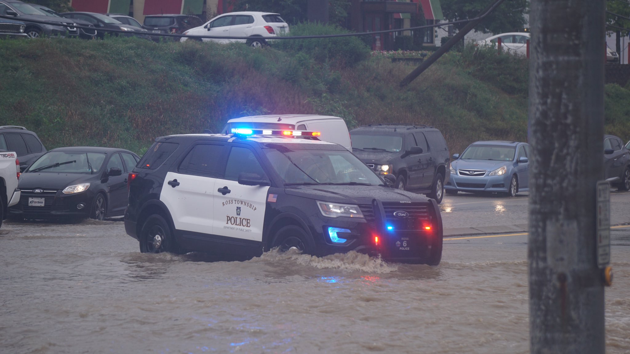
According to the national weather service, in 2018 Allegheny County experienced the most rainfall ever recorded in a single calendar year. Midway through 2019 Allegheny County is on pace to shatter the 2018 all-time record. Two years in a row Pittsburgh is facing the most unprecedented rainfall totals in its history. Over the past year and a half our region’s abundance of water has been more than any of us ever wanted. News reports have been a near constant stream (no pun intended) of localized flooding stories. The flooding has become so frequent that it became running joke on Twitter that Pittsburgh made it a whole single day without a localized flood. In the vein of your classic workplace safety sign, the joke contained a photoshopped image of a giant billboard on the cliff-side of Mt. Washington stating: “01 Days Without Localized Flooding.” Shortly thereafter the number flips back to “00” with the 1 tumbling down off the Mt. Washington cliff-side.
While some of us may find a photoshopped image on Twitter helpful comedic stress reliever, we can likely assume that the people’s lives directly impacted by repeated flooding do not and likely live with continual emotional stress in constant fear of the next severe rain storm.
Localized flash flooding in the Pittsburgh region is a serious epidemic and chronic illness. And its citizens are subject to all of the side effects and symptoms. It will take the entire region to come together to develop a cure.
In response to these repeated events, we’ve decided to take it upon ourselves to chronicle every flooding event as they occur using interactive webmaps on this blog and we will continue to do so for the foreseeable future. Every flooding event will be documented on the archives page, which will be continually updated. As many of the pictures and videos show, these are dangerous and life threatening events. In many of the videos, streets are filling with water from overtaxed drainage systems. Vehicles are being swept away by flood waters. Homes and businesses are being inundated and ransacked by high water, debris, and mud. In some events, people are being rescued from their cars and homes by emergency responders. Tragically, people’s lives have been lost in recent years due to flash flooding.
All told, the damage to property are likely in the tens of millions. This doesn’t include harder to quantify costs such as personal stress and trauma caused to victims, cleanup and repair costs, hospital bills, missed days from work, cost for emergency personnel, and the like. Nor does it take into account landslides due to saturated ground due to saturated soils.
While 2018 and 2019 have been bad years for flooding, all hope should not be lost for the future. We should not give up finding ways to mitigate flooding to our region. Addressing flooding issues is nothing new to the Pittsburgh region. Our ancestors have had a long history of rolling up their sleeves and finding ways to solve grand challenges.
The history of tackling Pittsburgh’s flooding problems can be traced back to the early 1900s. At the turn of the twentieth century the three rivers were regular source of devastating flooding and near misses. During this era flood waters regularly over-topped the river banks and flooded downtown businesses and industry along the shorelines upstream and downstream. Flooding became so bad and disruptive to business and industry that the Flood Commission of Pittsburgh was established with the first president of commission being none other than Howard J. Heinz, president of the H.J. Heinz Company.
The commission primarily consisted of the region’s foremost businessmen, engineers, and other esteemed professionals and would later expand to include city and county elected officials. As stated in their 1911 report “Safeguarding Pittsburgh from Floods”, their objective was to “carefully investigate and determine upon plans to protect Pittsburgh from floods and the damage resulting therefrom.”
At its core, the Flood Commission of Pittsburgh (which would later be renamed the Citizens’ Committee on Flood Control) was a citizen backed grass roots effort championed by elite local business leaders. They would eventually expand to include 400 additional flood control committees across several counties in the Pennsylvania-West Virginia-Ohio tri-state area. The collective efforts of prominent business leaders and the general public ultimately led to the United States Army Corps of Engineers constructing flood control reservoirs upstream of Pittsburgh.
Still today, the dams and reservoirs are modern engineering marvels of human might that were constructed to address a decades long problem. The ultimate vision and construction of the dams were a grand challenge overcome by the ancestors that laid the foundation for our region’s prosperity. To get the reservoirs approved by Congress, the commission overcame the great depression, two world wars, and various political obstacles at both the state and federal levels. All told there are now 13 flood protection reservoirs upstream of the point at Pittsburgh including the mammoth Allegheny Reservoir and Kinzua Dam, one of the largest dams east of the Mississippi River.
The construction of the 13 flood control dams fulfilled the original vision of the commission several decades prior. Well actually, the original flood commission recommended 17 reservoirs upstream of Pittsburgh, but who’s counting after literally hundreds of millions of dollars spent? The dramatic story of Pittsburgh’s early 20th century flood control movement is wonderfully depicted in “The Politics of Pittsburgh Flood Control, 1908-1936” and “The Politics of Pittsburgh Flood Control, 1936-1960” both authored by Roland M. Smith of Carnegie Mellon University.
The authors of this blog retell this story to inspire us to take on today’s grand challenge with respect to Pittsburgh flooding. We need to start tackling localized flash flooding together as a collective region. Individual municipalities cannot do it alone as rain that falls within our watersheds does not follow municipal boundaries. We believe we can do this. However, we need leadership who are passionate and knowledgeable about the issue, we need political backing and support, we need community organizations and the public at large to support the mission. We need to establish another Flood Commission, this time the Flood Commission of Allegheny County, that is willing to carry the torch and listen to the public and answer their tough questions. We need to establish a funding mechanism and allow for public oversight of those funds so that they are clear, transparent, and equitable to all people in the county. We need to develop partnerships and working relationships with the Federal Emergency Management Agency and the United States Army Corps of Engineers so that flood mitigation projects get constructed and receive federal backing and grant assistance. We need to better understand how flooding behaves within our watersheds and where projects will be most beneficial utilizing previously conducted and on-going studies to inform their placement. After a regional project is constructed we need a responsible regional flood control agency that will be charged with ensuring the on-going maintenance and upkeep of the project.
It should be mentioned that there are several agencies and municipalities in Allegheny County that are doing fine work attempting to address flooding as best as they can within their own individual communities. We applaud these communities, however they cannot be in the minority in this effort.
If we are to address flooding it will require regional and countywide coordination that is focused on watershed boundaries and not political boundaries.
Elsewhere across the nation countywide publicly backed initiatives to address flooding have been established with great success. Some of these places include: Seattle, Chicago, Denver, Houston, Phoenix, and Portland. They’ve all put aside their individual political differences and have taken on a grand challenge for making their communities a better place to live.
So why not Allegheny County and Pittsburgh? Furthermore why not all counties in Southwestern Pennsylvania that are negatively impacted by flooding? As past history shows, finding answers to the county’s localized flooding won’t be easy. The planning and construction of flood mitigation projects may take several decades, but we have to start somewhere. It’s a grand challenge but also a grand opportunity to make our region a better place for everyone. If we are to begin to address this regional epidemic it will require everyone in this region to come together and buy into the cure.
The cure begins with the re-establishment of a regional flood commission tasked to take on this grand challenge. Let’s roll up our sleeves and get started, just like this region’s ancestors.
I sometimes like to think of the vast network of streams and rivers as a wormhole portal of water. The portal is a transportation conduit on the surface of the Earth that moves water from the sky, back to its original birthplace, the ocean. Humans manipulate that transportation portal in all sorts of interesting ways. We dam it up in places, create massive levees and flood walls, harness it for energy, move it around in canals, create billions of miles of underground pipes, aqueducts and pump it to all sorts of weird places. The vast network of stream portals are always flowing, 24/7/365 around the clock. It’s always in motion like some planetary cosmic dance between nature and humans.
“No man ever steps in the same river twice, for it’s not the same river and he’s not the same man.”
The water portal of streams and rivers are in a constant state of flux, as are we humans. As years, generations and epochs pass by, the water moves from one place to the next. As it moves, we try our best to follow along.
Some of the most mesmerizing images of this planet are time lapse satellite imagery of untouched streams and rivers in remote portions of the planet. Even without our human intervention, the great water portal transporting water from the sky, back to the ocean is in a constant state of turmoil, twisting and turning, flooding and eroding the landscape with each passing day and year. Take a look at this time lapse of the Ucayali River located in the mountains of Peru. Foreshadow warning: we’ll come back to Peru later on in this post.
Landsat Satellite Time Lapse Imagery of the Ucayali River near Pucallpa, Peru
There are some universal truths when it comes to the planet’s stream portals. First, it should be recognized that flooding along and near the portals is imprinted into this planet’s DNA. I think we sometimes lose sight of that fact, and think flooding can somehow be “stopped”. Second, being in close proximity to the stream portal, especially when the sky really opens up, can be very dangerous place to be. Third, water is a powerful force, perhaps the most powerful force on this planet, it literally carves valleys and mountains.
Mapping Pittsburgh’s Lost Historic Stream Portals
If you’ve at all been reading this blog you know how much I love crafting posts around our environmental history and legacy. Pittsburgh’s history is especially amazing given our importance on the world stage in driving the industrial engine of our modern world. Perhaps the era I’m most captivated by is the mid to late 19th century, as America and much of the western world transitioned from an agrarian economy built around small farms to an industrialized economy built around global capitalist corporations. How this shift in work productivity resulted in the mass migration of populations into cities looking for employment, stable income, food and shelter. Population exploded in Pittsburgh, like many other American cities.
One of my absolute favorite things on the internet are the digitized G.M. Hopkins Company historic maps on Historic Pittsburgh’s website.
Screen Capture of Late 1800’s Pittsburgh Historic Maps
The G.M. Hopkins Company was a civil engineering and surveying company in the 19th century that made stunningly beautiful hand drawn real estate plat maps all over the eastern portion of the country. You can buy one on this website for a cool $1000.00. Most of them are locked safely away in city archives, university libraries, or museums. What I love about these maps is not only did G.M. Hopkins Company map real estate boundaries, but they also mapped with incredible detail streams, rivers, lakes, and ponds. Many of which no longer exist due to human interventions.
One rainy Sunday a couple weekends ago, I decided to digitize the locations of all lost historic stream portals drawn on the G.M. Hopkins maps of the City of Pittsburgh. Below are the depressing results of the locations in comparison to what is left today. Here is a link to an interactive GIS map I created if you want zoom in on areas of the City and display the old maps.
Map of Historic 19th Century Pittsburgh Streams
Map of Remaining 21st Century Pittsburgh Streams
What Happened to Pittsburgh’s Historic Stream Portals?
The simple and most straight forward answer is they were put into sewers.
It might be a natural inclination for some reading this to look down upon the people of this era for lacking any sort of environmental consciousness or education. Undoubtedly burying or encapsulating a stream within a sewer would be illegal under today’s Clean Water Act laws. But I would encourage folks to instead reflect for a moment on the challenges Pittsburgh residents faced and their living conditions at the time.
Perhaps the most difficult part of the transition from rural agrarian lifestyle to industrialized urban city centers was access to clean and reliable drinking water and sanitation. In the late 19th century, cities were just not ready nor equipped to handle the mass influx of population. Large concentrations of humans congregating into one spot in a short amount of time without proper planning will usually result in a big large mess. In the 19th century, water born illnesses such as cholera and typhoid fever were rampant throughout cities. Many people were violently ill and they didn’t really know why until John Snow studied and mapped cholera outbreaks to drinking water wells in London. Book recommendation: The Ghost Map: The Story of London’s Most Terrifying Epidemic–and How It Changed Science, Cities, and the Modern World by Steven Johnson.
Now as promised earlier let’s go back to Peru for a quick side story. Believe it or not, I’ve had typhoid fever in the past, and let me tell you it is one brutal wet and wild ride. In 2007, I went to Machu Picchu with my then girlfriend (now wife), and I contracted salmonella, and developed typhoid fever. Four days of hell. I had the worst stomach pains, could not hold down any liquids, was covered head to toe in muscle and body aches, and had chilling sweats with a 103 degree fever. I had to be taken to the hospital in an ambulance in Cuzco, Peru on Thanksgiving Day where I was given an IV, antibiotics, and an overnight stay with clear soup broths and chicken. Had I been living in 19th century Pittsburgh, without the aid of modern science and antibiotics, there is a semi-decent chance I would have died. Silver lining to this story: I still got to see Machu Picchu, which happened a few days before said hospital incident. Silver lining part two: the hospital bill in Peru was a grand total of 230 American dollars including the ambulance ride, easily $20000 in America.
Little Did He Know Montezuma Was Plotting His Revenge Under His Green Plastic Poncho
Now back to the 1800s in Pittsburgh. Below are the typhoid fever mortality statistics from at entering the 20th century, prior to and after the implementation of the Pittsburgh Water Filtration Plant (today’s Pittsburgh Water and Sewer Authority).
“The resulting pollution gave Pittsburgh the highest death rate from typhoid fever of the nation’s largest cities – well over 100 deaths per 100,000 people from 1873 to 1907. In contrast, in 1905, the average for northern cities was 35 per 100,000 persons.”
And it wasn’t just human waste, it’s also important to remember that in the 1800s the automobile has yet to enter the picture. Horses are a significant aspect of ground transportation in cities and are everywhere also making mess. From Clay McShane and Joel Tarr’s “The Horse in the City: Living Machines in the Nineteenth Century.”
(Can I also just briefly mention how much I love Joel Tarr? If you ever get a chance to hear him speak in Pittsburgh, I highly recommend you do so. I guarantee you will be thoroughly captivated.)
“While the nineteenth century American city faced many forms of environmental pollution, none was as all encompassing as that produced by the horse. The most severe problem was that caused by horses defecating and urinating in the streets, but dead animals and noise pollution also produced serious annoyances and even health problems. The normal city horse produced between fifteen and thirty-five pounds of manure a day and about a quart of urine, usually distributed along the course of its route or deposited in the stable. While cities made sporadic attempts to keep the streets clean, the manure was everywhere, along the roadway, heaped in piles or next to stables, or ground up by the traffic and blown about by the wind.”
And later on…
“Nineteenth century urbanites considered the stench or miasmas produced by the manure piles a serious health hazard, but cleaning was sporadic at best. Manure piles also produced huge numbers of flies, in reality a much more serious vector for infectious diseases such as typhoid fever than odors. By the turn of the century public health officials had largely accepted the bacterial theory of disease and had identified the “queen of the dung-heap” or fly, as a major source. Inventors and city officials devised improved methods of street cleaning and street sweeping became a major urban expense. Increasingly, however, it became obvious that the most effective way to eliminate the “typhoid fly” (so named by L.O. Howard, chief of the Bureau of Entomology of the Department of Agriculture and a leader in the campaign against flies), was to eliminate the horse.”
Pittsburgh streams were buried and inclosed within sewer pipes in the late 1800s largely to alleviate the rapid spread of water born illnesses and save lives as quickly and cheaply as possible. Conditions in many places, especially immigrant tenant housing neighborhoods, were from all indications deplorable. Pittsburgh was not at all prepared to handle the mass influx of migrant populations. The 21st century viewpoint of protecting and preserving the beauty of natural streams would have been laughed out of the room for suggesting such an idea. People everywhere were sick and dying. Terrible illnesses and death by close friends and family members were likely a very regular occurrence. Wretched odors, feces and urine (both human and non-human), grime and general neighborhood squaller were in abundance throughout much of the city.
Eliminating the stream portals was a no-brainer to our recent ancestors. It was the most efficient and simplest solution to addressing an immediate health crisis.
Buried Stream Portals at the Expense of Future Generation Safety
Unfortunately, the reality is we unintentionally created a flooding problem that is nearly impossible to undo. Taking the stream “back out of the sewer” is an engineering technical nightmare. It requires ripping up entire neighborhoods and physically untangling the spaghetti network of sewer pipes from the stream. Once untangled, we then somehow need to bring the stream back to the surface. Then once the stream is at the surface, there’s the other logistical issue of where to exactly put it. Just about all of these historic streams now have occupied homes and businesses sitting on top of them. The Four Mile Run, neighborhood in Pittsburgh is one of the more prolific examples that has gotten a lot of attention, but there are many more.
There’s numerous other technical challenges such as conflicting utilities, dealing with existing railroad easements, and impedances from 20th century interstate highways. All of these issues add up to millions of dollars to find a way to restore the lost stream. You have to give credit to the Pittsburgh Water and Sewer Authority for attempting a Herculean modern engineering challenge of our time in the Four Mile Run neighborhood.
Unfortunately I do not have any ready made solutions to communities next to these historic streams. Streams are meant to flood, and mitigating flooding in these areas is not inexpensive. Your home or business is flood prone in part due to an 19th century health crisis.
Unfortunately, many residents are not even aware that a historic stream is directly under their feet when they decided to call that neighborhood home. I can only hope these maps educate the public as to where our historic stream portals once existed, at least according to our best knowledge from G.M. Hopkins Company real estate maps.
In closing, everyone should take it upon themselves to perform necessary actions to protect your homes from increased risks of urban flash flooding. Having a depressed sunken driveway below street grade to park your car in a basement garage is a very bad idea. Consider consulting with a plumber and ask about backwater prevention valves to prevent the historic stream in the sewer from backing up into your basement through your sewer house connection. Make sure any sunken basement windows have a sill and are flood proofed. If you can, consider walling off all basement windows.
These are just some ideas for a situation that is likely to get worse in the coming decades.
When it comes to being a progressively minded flood protected community perhaps nothing is more important than instituting a stormwater fee that is based on impervious surfaces.
At the basic fundamental level, stormwater fees set the tone for the town. That the residents of the town are going to take impervious surfaces seriously. I personally like to refer to impervious surfaces as “flood out your neighbor” surfaces. That’s really what they are doing. Impervious surfaces is sugar coating it in my mind. Impervious surfaces dramatically alter the balance of the water cycle sending more flow faster to residents down hill.
This past month I wrote a public OpEd/Essay for Public Source on why stormwater fees are the most fair and logical approach to actually putting a fair price on flooding. Please go and read it if you haven’t already. You can also get a feel for what I look like when I am dead serious about a subject. People who know me, know that I never look that angry, except when it comes to flooding. Boy, who knew I could look like a way less cooler and nerdier water version of Clint Eastwood mixed with Johnny Cash. I think it was the 7AM shadows and lighting as well that helped with the effect.
(Photo credit: Public Source and the super amazing photographer Lindsay Dill)
Anyway, I was limited to 1500 words in the op-ed so I wanted to write some more about stormwater fees here on the blog. I really could go on for days about this subject if I wanted, which is why I likely had Public Source editors going insane with my first draft. Side note: If I loose my marbles and I ever become a Senator some day, my filibuster speeches will be my internal ravings on stormwater fees and incentives.
As I stated in the essay, stormwater fees are needed so that society fairly charges individuals based on the amount of impervious flood out your neighbor surfaces that you or I own. There’s a concept in Economics 101 called “unpriced negative externalities”. You’re probably asking yourself what the heck is this gobbledygook economic speak language “unpriced negative externality” and are we really getting into Economics on an already supremely nerdy enough flooding engineering blog? Yes. Yes we are snarky reader. So pay attention.
Beuller?
An economic negative externality is an externally placed negative human behavior that results in a detrimental cost to society. To help explain the concept, let’s look at an economic negative externality in an example.
Since this blog is named after Pittsburgh and our great city was once called “hell with its lid taken off”, let’s consider air pollution from a steel mill in our example.
Steel mills notoriously pump many different kinds of pollutants into the air. While the mill has to pay for operating costs such as electricity, materials, wages, etc., the residents living around the factory will pay for the brunt of the negative impacts of the pollution. For example, the residents around the mill are likely to have higher medical expenses due to asthma, generally poorer quality of life due to increased smog and noise from the mill, reduced aesthetic appeal of their town resulting in lower home values and taxable income, and general degraded infrastructure such as poorly maintained roads due to lower taxable income. The production of steel and its resulting air and noise pollution are a “negative externality” to the people surrounding the factory.
The steel mill doesn’t have to pay for the effects of the pollution but someone has to (i.e. the residents living in the nearby towns). However, air pollution from steel mills are regulated under the Clean Air Act so they are not a completely true “unpriced” negative externality. There are financial penalties to the steel company if the air pollution and the costs born to the residents are too great (eh-hem 👀 U.S. Steel 👀) . Whether air pollution violations are priced correctly is another matter for debate, but air pollution from mills do have a price when they exceed EPA Clean Air Act emissions standards.
This same example can also be applied to stormwater fees and impervious flood out your neighbor surfaces. The more impervious surfaces you or I own, the more negative costs there are to society. More impervious surfaces means more pollution from washoff, more flooding, more cleanup, more days missed from work, more overtime pay for emergency responders, more infrastructure and on-going repairs needed to manage the extra runoff. All of this costs money to society and are an economic negative externality placed on all citizens.
However, one of the main differences with air pollution generated from a steel mill and stormwater generated from impervious flood out your neighbor surfaces, is that impervious surfaces are an “unpriced” negative externality. In most municipalities in Allegheny County, including the City of Pittsburgh, there are no financial ramifications for an individual to have acres upon acres of roofs, paved parking lots, and driveways even though these surfaces have a major negative economic cost to society.
Stormwater fees based on impervious surfaces are about removing the “unpriced” from the term “unpriced negative externalities” and making sure that land owners with MORE impervious flood out your neighbor surfaces pay proportionally for addressing the negative cost to the rest of society. This is about fairness. This is about equity. You might not like the idea of stormwater fees, but without question they are the most fair and equitable means of addressing our stormwater and flooding issues.
While we are on the subject of economics let’s toss in some Psychology 101 while we are at it.
It is said by leading psychologists, including the esteemed Dr. Peter Venkman, that people are only motivated to change based on intrinsic and extrinsic incentives. In other words, the old tried and true saying “What’s in it for me?”.
Intrinsic incentives are internally placed in your own head; I do sit ups even though I don’t want to because I really want those six pack abs (spoiler: I will never get them no matter how I may try).
Extrinsic incentives are externally placed by society; I move my car every other Monday morning for street cleaning even though I don’t want to, but I also don’t want that 30$ parking ticket. Ok I’ll move it, I have an incentive. Hey, the street cleaner guy never even showed up! I might just call the City about this – eh that sounds like a lotta work. I’ll just complain on Facebook instead. I mean I just moved my car and walked almost 100 steps for nothing. But at least I didn’t get that 30$ parking ticket. Dang extrinsic incentives tricked me into walking 100 steps and wasting 15 minutes of my life for nothing!
Any stormwater fee that is worth its salt will have an extrinsic incentive tied to it to allow the property owner to reduce their stormwater fee by either:
A.) Removing/bulldozing some or all of its impervious flood out your neighbor surface area (Hey, do we really need THIS much parking? 1000 parking stalls for a new Best Buy? Does anyone even shop at Best Buys? I don’t even think we have a 1000 electronic items in the store anymore. Actually, as of today this building isn’t even a Best Buy. It’s now a comic book store.)
Or…
B.) Installing rain water management green infrastructure features that reduce their stormwater contributions (see this post here).
Whelp, that’s all I got for today on stormwater fees. I won’t filibuster you anymore today on this blog about them. I put my contact info at the bottom of the Public Source OpEd because I encourage people to reach out to me on this subject.
I know people are likely to get upset about a “new” fee on their bill. But I welcome the discussion even if it means a few ultra far right wing anti-government psychopaths sending me death threat emails.
Happy to talk to anyone about this subject.
But be forewarned, once I get started I may filibuster your evening.
On July 7th and 8th we had back-to-back days of flash flooding in many parts of the region. Back-to-back days with flooding aren’t particularly abnormal if you’ve been living long enough in Pittsburgh. What I found most unusual is how over the past several years it seems as though the first week of July appears to be an especially flood prone time of the year. Just about every year I can practically set my watch for the first week of July based on severe and dangerous thunderstorms.
If only there were a website I could go to look back and confirm if my suspicions are correct. If only there was someone out there documenting these events and writing them down in a convenient central location. Hint: it’s this website -> https://pghflood.home.blog/archives/
Let’s take a look back at some of the early July flooding events that have happened in recent years.
July 8, 2021
Pleasant Hills: Numerous roadways flooded – Hi Tor Dr, Broadway Dr, W Bruceton Rd, Cavan Dr, Arbor Ln, Temona Dr, Mowry Dr & Winifred Dr
Come the first week of July, hang the stars and stripes, shoot off your fireworks, and eat as many hotdogs physically possible just like our national American hero Joey Chestnut. Just also remember to have the sandbags and life jackets readied for deployment.
One common theme from these rain events is just how isolated they are spatially. They seem to find an area and drop torrential amounts of rain in a short amount of time in relatively small area.
Here’s a look at the center of the rainfall of these storms.
Date
Rainfall Inches
Duration in Hours
7/7/2016
2.00
1.0
7/6/2017
3.00
1.0
7/2/2018
3.00
1.5
7/4/2018
2.75
1.5
7/5/2018
3.00
1.5
7/6/2019
2.25
0.5
7/7/2021
3.00
1.0
7/8/2021
1.75
0.5
Call it climate change or global warming or cloudburst rainfall or tropical Pittsburgh monsoons. No matter what you call them, these types of events are now part of the new normal and are here to stay just about every summer here in Pittsburgh.
The question becomes how do we begin to better prepare ourselves for this future?
This is Part 3 in an exploration of how humanity’s actions in our sandbox have created a more flood prone condition.Here’s links to Part 1 and Part 2. But really you can go ahead and read Part 3 without reading those parts if you want. You know, just do what feels good. If you read this one, and like it, go back and read the first two. Or do a catch up and read the first two, then read this one. I’m probably making this preamble more confusing than it needs to be. This is the third part, just read itin whatever way floats your floodboat.
“We are all responsible for flooding.” – Tom Batroney
Every one of us has a hand in the blame. You, me, and the pointing kid, which metaphorically is me, I guess. That cool looking kid with that smirk. Wipe that smirk off your face kid, you are so responsible. Also that long haired person, who I am assuming is a girl, and is not paying attention to this made up conversation, is also responsible.
The problem is when flooding happens, it is always thought of someone else’s problem to fix. Not yours or mine, but someone else’s. That blame usually falls onto the shoulders of the town mayor, manager, or engineer of said flooded town. But in reality, she is but a single blade of grass in the vast open field of blame which has contributed to this flooding mess.
As the saying goes, and is true more often than not, when you point the finger of blame at someone else, there are always three pointing back at you. Don’t believe me? Just take a look at the pointing kid again.
Society has done tremendous alteration to the natural water cycle to promote a more flood prone condition. We’ve done everything we can to increase the volume and speed of the rainwater runoff. Our goal has been to get the water away as fast as possible. To send it downstream to become someone else’s problem to deal with. Go ahead, you have fun dealing with this torrent of water, downstream town engineer.
How did this happen?
We did it in the name of industrial progress and the sprit of American freedom. In less than a century we cut down swaths of forests using newly discovered industrial engines fueled by dead dinosaurs. After the forests were cut down, using those same engines, we then paved over the land block-by-block and created cities to house an explosion of newly arriving immigrants. When those cities became too crowded, we then created networks of transportation highways to sprawling suburban developments each with their own driveway and two car garage.
That’s the American story over the past couple centuries condensed down into one single paragraph.
It’s also a story of hard work and innovation put in over many consecutive decades. Yeah, you can include some world wars and how America saved western democracy from fascism and communism. That was a pretty big deal, I’ll admit. Or how Americans voluntarily strapped themselves inside explosive rockets in order to collect some rocks on the moon. That was also freaking amazing. But those accomplishments don’t define America to me. In my mind, we’re defined by the sweat and ingenuity supplied from a rich diversity of immigrants from all corners of the world. It’s the collection of hard work from those diverse immigrants that defines America. That’s what America is about.
But all that hard work in such a short burst did have some draw backs.
In our incredibly fast haste to build this country very few of us considered the ramifications of replacing centuries old rainwater absorbing forests with impermeable hardscapes of concrete, asphalt, and roof shingles. Not at least until it was too late. Now when heavy rain happens, instead of rainwater being absorbed by forests, it now floods out your downstream neighbor. This is the situation we’ve created and why we are all to blame.
Take for example the single family home in a residential neighborhood. In other words, the 20th century ideal piece of American land.
We’ve gone from this…
To this…
The single biggest cause for flooding is the increased amount of impermeable flood-out-your-downstream-neighbor surfaces. The volume and speed of the rainwater runoff dramatically increases when the land is transformed from forest to roads and buildings and parking lots.
So what can we do about this? Let’s be clear, in no way am I proposing that the solution is to stop human progress and development. I’m not some anti-industrial-machine-smashing-luddite wishing to demolish residential suburban homes and replant them with rainwater absorbing forests in the name of reducing flooding. No, that is not what I am suggesting at all.
What I’m suggesting is we all need to understand the historical context of how we’ve severely altered the water cycle. Using that context, each of us needs to do our part to restore the water cycle back to a forest-like state, or at least as close as possible to a forest-like state.
In Part 2, I wrote about how in the 1970s laws were put in place to ensure that rainwater is properly managed from new development. These laws were put into place to ensure that new land, when developed, “acts” like a natural forest in order to mimic the natural water cycle. The essence of these laws are to slow down the rainwater runoff and absorb it on a portion of the property.
Unfortunately, these laws do nothing about the existing land that has already been developed. Which is the overwhelmingly the vast majority of the land, at least in the Pittsburgh region. So what are we to do about all the existing properties that are already developed?
Part of the solution is that all of us need to pitch in and install rainwater absorbing features for our properties, wherever feasibly possible, when there is space available.
Take for example the single family home with a large front lawn shown previously. Rather than sending that water as fast as possible to your downstream neighbor, the property owner could disconnect the corner roof rain gutter, install a rain garden, and fill it with plants and a tree. Research has shown, that if installed properly, a rainwater absorbing garden will do a pretty decent job at mimicking the water cycle of a small “forest” for most rain events (see reference at bottom). Rainwater runoff from roads could also be absorbed into roadside natural rain garden swales that would catch and slow down the water.
In addition to single family homes, large parking lots are a massive single concentrated source of rainwater runoff and increased flooding. Large parking lots are like an amusement park roller coaster ride adrenaline rush for speeding up rainwater runoff. We need to thoughtfully consider balancing the need for MORE PARKING! with more thoughtful consideration for flooding out our downstream neighbor. For decades, American society has long had a heavy addiction to MORE PARKING! There never seems to be enough parking to satisfy some folks. That mindset and addiction needs to be kicked with a twelve step program. We need to sacrifice some parking spaces and our convenience for the greater good of restoring the water cycle and helping our downstream neighbor.
The great news is that there are people that are aware of the more flood prone condition we’ve created in our sandbox. Some individual home owners have voluntarily installed rainwater absorbing features on their properties. Some businesses and communities are reconstructing parking lots to absorb more rainwater. And yes, some are taking away a couple parking spots in the process (gasp! the horror!).
Why?
These individuals realize it’s the right thing to do if you love and care at all about your downstream neighbor.
By installing these features, these folks get the peace of mind in knowing that they are no longer contributing to the flooding problem that we ourselves have created. They’ve removed their own impermeable flood-out-your-downstream-neighbor surface from the gears of the massive societal flooding machine.
If done right, installing rainwater absorbing features are a beautiful thing and feeling. They are a full-on expression of love and consideration for your fellow neighbor that somewhere downstream might be flooded the next time it rains heavily.
People who are installing rainwater absorbing features within their own personal sandboxes are doing their part to help. Even if it’s a very small part. They do this because deep down they know if a lot more people did it, it may even help prevent the next flood and help a person in need.
In Part 4, I will be writing about some of my favorite rainwater absorbing examples that are taking place right here in the Pittsburgh region.
There’s an old adage that holds true like the sun rises in East. It goes, “When everybody is responsible, then nobody is responsible. When nobody is responsible, nothing gets fixed.” And, in my opinion, it’s very applicable when it comes to addressing and mitigating regional flooding issues.
Previously in Part 1, I wrote about why we all have a part to play for why there’s so much flash flooding in the Pittsburgh region. Especially when it comes to the stormwater generated from our homes and businesses.
Over the past century we have done tremendous harm to the way we have altered the water cycle and created a more flood prone condition. We’ve buzz-sawed swaths of forests in a matter of decades. We’ve constructed miles upon miles of smooth rainwater “impermeable” surfaces such as roads, roofs, and parking lots. Or “flood out your downstream neighbor” surfaces because that’s really what they are doing.
One of my favorite Twitter follows is by a local yinzer named Conor Tompkins. He makes really awesome data visualization maps. And if you know anything about me or this blog, you would know I’m all about this kind of stuff and Conor is a great source of inspiration. One of my favorite Twitter posts from him is on the increased land development in Allegheny County over its history.
As you watch these animations, think about the ramifications of an altered water cycle. Think about how for each new land parcel put into our sandbox, how the amount of water is increasing and accelerating down into our steep valleys. Think about how as each new road, roof, or parking lot is built, more and more water is unable to be absorbed by forests and nature.
Most importantly, think about the people living at the bottom of our watersheds. How they are powerless to the new development happening upstream of their homes and businesses. How all these additional “flood out your downstream neighbor” surfaces are impacting the lives of those folks. The people living communities along Saw Mill Run in Pittsburgh, or along Girty’s Run in Milvale, or Pine Creek in Etna, or Chartiers Creek in McKees Rocks, or down in “The Run” in the famous Big Jim’s territory in Pittsburgh.
I’ve often thought to myself why are all the valleys in the Pittsburgh region named after some kind of “Run”? Maybe it’s because when it rains hard that is what you should do. Run. Run for your life.
So what have we as a society collectively done about this issue? You may be wondering why aren’t laws in place to help prevent this issue from happening? Why yes, yes inquisitive reader, there are laws. Laws that govern what we can and cannot do in humanity’s sandbox. Let’s talk briefly about those laws. Let me put on my old timey lawyer wig and black gown for the rest of this post.
I think most of us have heard of the the most prominent water law in the history of this country. It’s the 1972 Clean Water Act. This is a federal law and was created to serve and govern all the states across this fine nation. The creation of this law was largely in response to late 1960s water catastrophes. The two most prominent both happening in 1969 with the five story high Cuyahoga River Fire and the Santa Barbara Disaster. In 1972, Congress passed The Clean Water Act in order to address our nation’s water pollution problems. Namely from the pollution being generated from industrial discharge pipes. The Clean Water Act does not address flooding issues but it set the stage for increased focus on protecting the health and safety of the public around the issue of water.
Stage left enter in the Commonwealth of Pennsylvania…
In 1978, Pennsylvania passed a law called “Storm Water Management Act“. The law recognized the detrimental impact increased development was having on the water cycle and the health and safety of communities. It marked the first time Pennsylvania government tried to step-in and course correct the damage the activities within humanity’s sandbox had done to the impacts of increased flooding. Within the Act the state General Assembly admitted the following:
“Inadequate management of accelerated runoff of storm water resulting from development throughout a watershed increases flood flows and velocities, contributes to erosion and sedimentation, overtaxes the carrying capacity of streams and storm sewers, greatly increases the cost of public facilities to carry and control storm water, undermines flood plain management and flood control efforts in downstream communities, reduces ground-water recharge, and threatens public health and safety.”
In response to this admission, the Act mandated two things:
That every county in Pennsylvania develop a storm water management plan detailing future flood mitigation efforts for each of its watersheds, and
That every municipality in Pennsylvania implement local storm water ordinances that regulate and limit the runoff from development within the municipality in a manner consistent with the applicable watershed storm water plan.
It was a huge step in the right direction, but in 2018 the law had to be amended (forty years later!) to include more forceful language stipulating penalties for those not complying with the law. Forty years! At least Moses was able to part the Red Sea and control the flood waters with the wave of his hand after wandering around in the wilderness for that long.
As it turns out laws without the ability to actually enforce them are really just nicely worded polite requests. Again see Moses and the Ten Commandments, we finally had to get those rules set in stone for them to work. For decades, some counties and municipalities were not abiding by the law set forth in the Storm Water Management Act of 1978. And get this, some are still not. See map below.
Act 167 Plans Status Map
Another super important thing to point out with the Act is that it doesn’t apply to development that existed prior to the enactment of the law. So unless you’re living in a newer community in a place like Cranberry Township, the vast majority of Pennsylvania cities and municipalities were developed long before 1978. In other words, the damage to the water cycle has already been done! So the municipal stormwater regulations don’t really do much for actually “fixing” the problem that was already created, it just limits it from getting worse.
This is the best analogy I can come up with. Follow along with me here…
Imagine your entire house is filled with faulty electrical wiring and is in high danger of burning down at any given moment. Every time you flip a switch you see random sparks are going off in the outlets and there are hints of burning smells wafting throughout the air. One fine sunny Saturday morning over coffee and pancakes at your breakfast nook you say to your significant other: “Hey honey, why don’t we finally get the first floor half bathroom remodeled this year and fix the electrical wiring in there. Hey, maybe this will also fix the wiring problem throughout the entire house…. I’m a genius why didn’t I think of this earlier!”
Unfortunately, I am sorry to inform you, no, you are not a creative home improvement genius in this analogy.
The house and the newly remodeled half bathroom burned down later that year. But hey, at least I let you escape from this analogy with your life. Actually, what really happened was that I broke into your house with an axe while you were peacefully sleeping unaware of the fire raging around you. I managed to battle through flames in my fireman suit, and heroically rescued you along with your cats. We jumped out the second story window into a makeshift cot waiting for us on the ground below. No need to thank me. It’s really no big deal. I’m just glad you and your spouse and your cats are safe. All in a days work in the life of Tom Batroney, fake volunteer fireman.
Moral of the story 1: Fixing the wiring in one half bathroom won’t fix the problem that already exists throughout the entire house.
Moral of the story 2: Fixing the stormwater from one development site won’t fix the problem that already exists throughout the entire watershed.
Moral of the story 3: I am not a trained fireman nor do I play one on TV. Please don’t call me if you have a fire. Call 911 and real trained professionals will come to your rescue.
Addressing flooding will require additional coordinated effort beyond just laws governing new development. The regulations from the 1978 Pennsylvania Storm Water Management Act were/are a step in the right direction but much more is needed to fix the decades of wrongs we’ve created in humanity’s sandbox.
Water is in constant motion on this planet. It’s always raining somewhere, it’s always traveling somewhere. Naturally flowing through streams, rivers, lakes, oceans and groundwater reservoirs. Somewhere along its path we animals grab a small of portion of it, ingest it into our bodies, and put it back into nature just ever so slightly more yellow where it can then go back on its merry way. Fun fact for the day: every glass of water you and I drink has dinosaur pee in it.
On average 0.08 inches of water in the form of rain hits the surface of the planet every single day. That might not sound like a whole lot but when you consider that the surface of the Earth is 197 million square miles. This equates to 274,000,000,000,000 gallons of water constantly raining down upon this planet every single day. Once a drop of water hits the ground surface, that drop can take almost a near infinite number of possible paths in its journey. Many drops will coalesce into small mountain brooks, then into streams, eventually into rivers, then into oceans, then evaporate into a rain cloud, and start the process over again. The process is truly amazing when you think about it on an existential level. The water cycle is like a machine that keeps on turning and pumping, around and around. Like coolant in a car but never ever stopping.
As the water spins and churns on our planet, the formations of the land will determine its course. The Earth itself under our feet charts the course for the rain over our head. Both the land and the water are mutually linked side by side. Water will always move over the land following what is called the “path of least resistance.” As water moves across the surface of our planet it really does not have time for small talk. Please don’t stop rain water and try to talk to it about the weather. It is the weather. Rain water has one mission, and one mission only, to get downhill and get there as fast as possible. Every single time for the past 3.8 billion years since this planet has had water, rain when it hits the ground, will take the most direct path for the least amount of effort. Take for example the Colorado River and the Grand Canyon. The Grand Canyon has been the path of least resistance for the water in the Colorado River for the past 7-8 million years. During those years, not once has one single water droplet said to itself, “You know, on second thought, today, I think I’m going to go around the Canyon today instead.”
Water is constantly spinning and circulating on this amazing planet, constantly looking for and seeking out the smoothest possible downhill ride with the least amount of resistance. What happens on the surface of the Earth dictates the path the water will eventually take. And if there’s one thing we humans are the grand masters at, probably better than any other known species, it’s manipulating the surface of this planet. The Earth in many ways is like our own little toy sandbox. How we manipulate the contents of that sandbox determines the eventual path water will take in its journey. We cut down swaths of forests, create massive dams, dig giant canals, construct massive underground water storage vessels. All of these things, and everything we do inside our sandbox, impacts the course water will eventually take.
Flooding happens when we put too much of the wrong contents inside our sandbox.
I’ve been writing about the modern history of the decline of our forests for the past few months on the blog. Why you may ask? Because there is no better natural occurring surface better at preventing flooding than a healthy thriving forest. And over the past two centuries we’ve gone and cut down most of them (see the blog posts here). Many of the forests that are remaining, especially in urban areas, are dwindling and often in poor health.
Take for example a healthy forest versus an agricultural meadow. In each of these sandboxes the water encounters a smoother surface with less obstacles, thereby speeding up the water. Remember water seeks the path of least resistance, always, every single time.
Suppose 1.5 inches of rain water falls upon each of these surfaces? What will happen?
For a healthy forest, on average 1.4 inches of rainwater will be captured and absorbed by the forest. The surface is very rough and has many obstacles (stumps, logs, and fallen branches). The water must take many paths to get to where it’s going. The more paths the water takes, the more chances it has to soak into the ground and absorb.
For a healthy agricultural grassy meadow, on average 1.2 inches of rainwater will be absorbed. Meadow grass, while still rough, provides fewer obstacles and is smoother than a forest. Also when it rains exceptionally hard, grasses can often get compacted and matted down, especially if trucks have driven over the grass before it rains.
If there’s one thing we humans really love to do in our sandbox it’s to create smooth surfaces. We all love to live in single family homes with a smooth roof, nice outdoor slate patio with a grill, and long asphalt driveway to park our 1.8 cars. Just like water, we humans also love to get to places fast using highways and roads. We love to buy stuff and park our cars in convenient shopping center parking lots. We call all of these surfaces “impermeable surfaces”, because rain water cannot permeate (i.e. pass) through them. If there is a complete opposite sandbox to a forest for rain water, it’s a smooth impermeable surface. Impermeable surfaces send water downhill very fast and have no obstacles for the water to encounter. Impermeable surfaces are the Webster’s Dictionary definition of the “path of least resistance.” (Don’t fact check me on that one, by the way. Hey, but if they aren’t they should be, Mr. Webster, whoever you are.)
Suppose 1.5 inches of rain water falls upon each of these types of surfaces? What will happen?
For a single family home in a dense residential neighborhood such as Pittsburgh, on average 0.8 inches of rainwater will be absorbed. Most water will hit the roof, enter a gutter, go into a pipe under the yard, and enter the common sewer pipe in the street. Water will sheet flow off the driveway and the street and into the curbside catchbasin where it will enter the common pipe. The rain water within that pipe will eventually make its way to the stream and it will get it there fast.
For a typical parking lot, on average 0.2 inches of rainwater will be absorbed by puddles and cracks. The rest will sheet flow over the surface, find the nearest pipe, and enter the stream. It will travel there even faster than the single family home.
Maybe instead of “Impermeable surfaces” we should start calling these types of surfaces “flood out your neighbor” surfaces. Because in reality that’s what they are doing, especially if the rainwater that hits them is not properly controlled. All of these surfaces add up within a watershed. Urban flooding is a death by thousands of individuals cuts. Take for example Saw Mill Run or Four Mile Run in Pittsburgh, two of the more prominent flood prone watersheds in our region. We’ve heavily developed these watersheds, with large buildings, homes, and parking lots. Over the decades, very little has been done to counter act the increased amount of water that is no longer absorbed.
In a lot of ways, the Earth’s surface is humanity’s toy sandbox. Even more so over the past century now that we have all these amazing combusting engines at our disposal to make it super easy to manipulate the land.
Our actions inside our individual sandboxes matter, especially when people and towns get flooded.
In a lot of ways, all of us are responsible for flooding.
P.S. A big huge thank you to my awesome graphic artist big sister, Karen, who helped me with creating these amazing sandbox graphics!
P.P.S. In part two we are going to talk about ways to counter act “flood out your neighbor” surfaces and what you can do to help reduce flooding.
Hey flood blog readers, remember that blog post about Twitter and flooding data I wrote over a year ago way back in September of 2019?
Ah yes… September 2019… those were the days. My mind harkens back to those distant far off memories when life was so grand, so simple, and so care free. The joyous events that went on in 2019 almost feel like a distant impossible dream right now….
(wavy lines and doo-loo-loo doo-loo-loo sound effects transporting us back to September 2019)
The scene: You (the reader), me, and my fake buddy Dave created for this fake story are all sitting at common high top table at Mad Mex having a few laughs and happy hour drinks after a long day at work. Our waiter, Jasper, is a slender darkly brown haired 20 something male with a ridiculous bar handle mustache.
Jasper: Hi my name is Jasper. I will be helping you with your orders today. I see you already got drinks at the bar. Can I get you any food to start while you look over your menus?
Tom: Hi Jasper. Sweet mustache. We would would like some salsa, chips, and guacamole for the table to share. Please place them all into single bowls which we will all share. No worries about separating the chips and dips by each individual person. Each of us will just reach our dominant hand into the bowls and dip at our own risk and at our own leisure. (Tom raises both hands and points with his left hand to his dominant right hand in the style of Vanna White and explains further) If the tips of our fingers and/or knuckles accidentally touch the other chips and dip contents it’s no big deal.We will continue eating them like nothing happened.
Jasper: Um… yeah, that’s the standard way we provide these things in 2019, sir. No need to be that specific with how we prepare our bowls, chips and dips and your personal hand sharing acumen. Be right back. (Jasper leaves the scene and under his breath utters to himself as he walks away)… What a weirdo.
Tom: Hey fake buddy Dave, can I get a small but yet very brief sip of your fancy 10 dollar craft double IPA cask barrel aged craft beer? I’d like to give it a try before I consider purchasing this ridiculously expensive and pretentious beer for myself. Don’t worry, it’s only a very small volume of beer that my delicate yet supple lips will be touching the rim of your glass and the contents of your liquid beer. Furthermore, the time it will take will only last approximately 1.6 seconds. That’s not nearly enough time to transfer my mouth germs to your glass, beer and eventually back to your mouth after I give you back the beer.
Fake buddy Dave: Wow thanks for the warning Tom. That was, um, very specific information. I really appreciate that. Sure thing, feel free to take a longer than a 1.6 second sip if you want as well. I 100% trust your hygiene and your lack of coughing and sneezing indicates that you have no potential illnesses present in your body. (Dave hands Tom the beer)
Tom: Thanks Dave. (Tom takes out his runners stop watch and times his sip of beer in 1.3 seconds)… Jeez this beer is really terrible, Dave. But here’s your $10 beer back 100% germ free and under 1.6 seconds as promised. See the time on my stopwatch? (Tom shows Dave and casually puts stopwatch back in his pocket like nothing happened.)
You (the reader): (sarcastically) Hey Tom, you are a weirdly strange guy with these explanations of food and beverage sharing hygiene protocols. Have you been transported from the future and know something we don’t? (You and Dave proceed to have a nice laugh at my expense.)
Tom: It’s funny you should mention blog reader. Why yes…. Yes I am…. And I’m here to tell each of you that you must enjoy these momentswhile you still have them! (Tom proceeds to gently put his hand onto your’s and fake buddy Dave’s hands and Tom looks deeply into each of your eyes. You and Dave look at each other freaked out and now are considering ending the evening short with a made up excuse.) I want you to listen closely at what I’m about to tell you… It’s very important… You must cherish this care free moment together with these delicious shared chips and dips…. (Tom is now squeezing very hard on each of your hands to the point of pain.) …CHERISH IT!
(wavy lines and doo-loo-loo doo-loo-loo sound effects transporting us back to 2020)
Oh how I miss 2019… those really were the days. It was the wild west of close personal friendships at high top tables and giant bowls of trust in the form of shared community guacamoles, salsas and chips and care free sips of expensive beers between friends. I believe that one day we will have that glorious human experience again. And quite honestly, if we don’t, I’m not sure it’s a world I want to live. So we must believe.
Where were we? Oh yeah, Twitter. I wrote a blog post about it back in 2019. It was only the third post of this young and blossoming flooding blog at the time, and it might be my personal favorite of them all so far. Feel free to read it again here:
Basically the jist of the blog post, if don’t have the time to re-read it again, is I took all of this flooding data from Twitter and used it to understand yearly and seasonal flooding trends in Allegheny County. In the blog post I also called out most of the Twitter sphere and the people on there as lunatics and nutjobs. BTW you can find me actively participating on Twitter. Feel free to follow me here: https://twitter.com/TomBatroney
Well, I took that blog post from 2019 and turned it into a polished professional presentation and journal paper for a major national water conference. A bit to my surprise, it was accepted. I was supposed to present my findings to a large room full of people in New Orleans in September 2020. But then 2020 had to go and happen. The conference went virtual and I was no longer able to have giant shared bowls of gumbo and jazz music with conference strangers. However, there is a silver lining. The conference going virtual allowed me to record my presentation for all of the world to enjoy. So here it is, world! Enjoy.
Unlocking Twitter and High-Resolution Radar Rainfall to Better Understand Urban Flooding
Author’s Note: This is the eighth part in a series of blog posts looking at the historical big picture of modern day urban flooding and the importance of trees. Go here for part one, two, three, four, five, six, and seven. Read this blog post on why I’ve decided to take on this project.
The destruction of the great North American virgin forests by European colonists in the 18th and 19th centuries was swift and ruthless. It was fueled by our engrained behaviors, religious doctrine, and the advent of steam engines capable do doing the work of hundreds of men by just a few. Trees were cut down by the billions without the slightest consideration for the ramifications.
In the mind of the devout Christians arriving in America, these trees were put here by God, therefore he wants us to cut them down. God created us in His likeness, therefore the Earth is mankind’s to do as we please.
This mindset to how we regard our only home, planet Earth, would begin to drastically change in the United States in the mid 1800’s.
And it was all because of our trees.
Westward expansion was an obsession from the beginning. America’s forefathers purchased land by the millions of square miles in the quest to reach the Pacific Ocean and create a continent spanning nation that was sea-to-shining-sea. We talked about the Pennsylvania purchases from the Indians in Part 6. Probably the most well known land purchase is Thomas Jefferson’s Louisiana Purchase from the French in 1803. The other big and lesser well known land acquisition by the United States was taken by force as a result of the Mexican-American War from 1846 to 1848. On February 2, 1848 the United States and Mexico signed the Treaty of Guadalupe Hidalgo which succeeded the rights to much of the American southwest, including the grand prize of California.
Soon gold would be found in northern California and a rush of new European settlers would pour into the Sierra Nevada mountain range. Hundreds of mining companies and make shift outfits would open up with the hopes of striking it rich. Very few in the end did.
In May of 1852, a man by the name of Augustus T. Dowd, hired as a hunter to supply fresh meat to the newly arriving workers, shot and chased a bear in Calaveras County located approximately 30 miles north of Yosemite Valley. Eventually Dowd’s pursuit of the bear led him deep into the forest grove where he would stumble upon the giant forest behemoths known as Sequoiadendron giganteum or the giant sequoia. Dowd would be the first white man to “discover” these trees, in what is today located in the Calaveras Grove in Calaveras State Park.
It’s astounding to think that just 170 years ago that much of California was largely an unknown frontier to many Europeans. And within this unknown frontier contained its otherworldly god-like trees, some of which are millennia in age that have been standing on Earth since the time of Christ.
Outside of the local native tribes, the world really had no concept about these ancient trees. Dowd and a small California newspaper, the Sonora Herald, would go on to publish Dowd’s account of his discovery that same year. Within a year, the story of giant trees would capture the imagination of the world and help usher in a new era of environmental stewardship.
The discovery of these awe inspiring forests would be the beginning of a new chapter in the history of America. It would be the beginning of an idea of preserving forests for the greater good for the planet. That mankind’s place on Earth maybe is not to cast dominion over all things, but rather to find a balance between nature and mankind that is reciprocative.
Remember August T. Dowd, we will be returning to him later on.
A changing of our collective belief systems as humans takes generations. Sometimes centuries. Especially when our beliefs are deeply engrained in our religious doctrines that are held with such great passion.
To change our beliefs often takes a series of many events stringed together, each building and growing off one another. Events that cumulate over time and crescendo into a mountain of evidence, rather than just one singular “A-HA!” lightening strike of a moment. Sure it’s fun to think about a singular moment changing the course of history. The apple hitting Isaac Newton in the head under the tree and discovering gravity. Or Benjamin Franklin’s kite being struck by lightening and discovering electricity. Or (spoiler alert) Doctor Emmett Brown while hanging a clock in the bathroom, slipping on the edge of the toilet, hitting his head on the kitchen sink, and conjuring up the idea of time travel using a flux capacitor powered via nuclear energy, and (spoiler alert part 2) everyday household kitchen scraps and garbage.
But those moments are sensationalized with moments of fiction for our own amusement. Or in the case of Doctor Emmett Brown 100% made up awesome fiction for our own amusement. We humans love to think of the possibility of the instantaneous “life changing epiphany” where all of our problems are solved on the back of an envelop or on a post-it note while sitting in traffic. Which reminds me of one of my favorite Onion articles of all time. But in reality, solving the world’s problems takes hard work and generations of human dedication.
Rarely do big life shifting changes happen in an instant other than in the movies. All of us are standing on the shoulders of giants in the name of future progress. We are continually building upon the foundation of past discoveries that inch us one step further on the path of progress named “who the hell knows where we are going and why the hell we are here.” (Author’s note: Who can I petition to make this a trail name in Frick Park?)
The same can be said for our trees. We understand them better and their importance to our survival on this planet thanks to the cumulation of advancements from multiple generations. Advancements that would eventually put emphasis on protecting nature and its trees. And this emphasis would lead to where we are today with national, state, and locally protected forests, public parks, and wild game lands.
But how did we get to where we are today? Actually protecting and valuing our trees rather than destroying them without regard? How did this change of consciousness come about?
We will need to rewind centuries to unpack this moment in the story of humanity. To me, it’s by far the most fascinating and uplifting look at ourselves as humans and how we have collectively worked together to change our behavior on this planet for the greater good.
The change in consciousness towards our trees begins at the same point in time as the story about its destruction. In Part 3 of in this series of blog posts you will remember that it was religious unrest in the 1600s and the Thirty Years War that drove many of Europe’s peoples to North America in the first place.
By all accounts, the Thirty Years War was a shockingly brutal struggle between Protestant and Catholic forces in the battle for Christendom in mainland Europe. The Thirty Years’ War is thought to have claimed between 4 and 12 million lives and that 20% of Europe’s people perished, with some areas seeing their population fall by as much as 60%.1
The war left Europe exhausted. Both in physical and emotional tatters at its conclusion in 1648. Seeing no end in sight to the bloodshed with neither Catholics or Protestants willing to give into the other side, a landmark treaty called the Peace of Westphalia was signed ushering in a new age of toleration among Christian religions. This toleration would help sow the seeds for the advancement of the Scientific Revolution and the Age of Enlightenment. Both of which would provide a platform for changing humanity’s consciousness. Both of which would usher in a new way of understanding our natural world and humanity’s collective impact on our planet and our trees.
The Scientific Revolution
While the Thirty Years War raged on in central Europe, two locations were spared from the brunt of the conflict. These countries were England and Italy.
In England, Francis Bacon just after the start of the war published his groundbreaking Novum Organum in 1620. This book would go on to change the course of the humanity and would determine a whole new method for reasoning, logic and truth. This single work would be responsible for “setting the dinner table” for generations of future scientists.
The scientific method or Baconian method would be outlined in Book II of Bacon’s Novum Organum. Most of us have heard of the scientific method and most of us have fallen asleep in some high school science class hearing about it. Mainly because by today’s standards of understanding the scientific method seems so obvious and boring. But in the time of Francis Bacon it was not. In the time of Bacon, witch trials were a real thing and at their peak of infamy. As were street magicians and alchemists looking to turn regular common metals into gold with philosopher stones. As was the selling of miraculous healing potions considered as the most advanced form of “medicine” at the time. Bacon saw these and was skeptical. He instead said verifiable proof was needed to establish truth, not magic from wizards, not spells from witches, not blind faith in potions from street corner healers. Real truth was obtained through meticulous observation using the study of our natural world, our surroundings and our collective experiences. Bacon was a naturalist and natural philosopher because he believed God’s truths were in nature, not in blind faith. It was a radical idea at the time, but very obvious now.
Over 1200 miles away in Italy a man by the name of Galileo Galilei was improving upon the invention of the refracting telescope in 1608 by Hans Lippershey. Lippershey’s original telescope magnified objects by three times, Galileo would dramatically improve upon the telescope with the ability to magnify objects by thirty times. Using the scientific method, an improved telescope, and decades of meticulous observations of the sun, the planets and moons, Galileo would go on the write Dialogue Concerning the Two Chief World Systems in 1632 right near the mid-point of the Thirty Years War. The Catholic Church was in a fight for its future, now it had a rabble rouser in its own empire questioning its holy scripture and teaching a sun centered universe. Galileo’s book would be banned by the Catholic Church, officially listed as heresy, and would land Galileo a court date. Galileo would be convicted at his trial and would live out the last nine years of his life under house arrest in exile.
Back in England a young child by the name of Robert Boyle was traveling the world as part of his upper class education. In 1641, at the age of 14, he would travel to Florence Italy where he would read Dialogue Concerning the Two Chief World Systems. This would be the passing of the scientific torch. Galileo would die that same year. But Boyle, captivated by Galileo’s mathematics and writings would carry on his legacy. Boyle would return to England becoming a titan of science and popular figure. He would go on to help establish the Royal Society of London for Improving Natural Knowledge.
By this time, the snowball of scientific discovery was in full effect. Other well known scientific titans of the era include Christopher Wren, Robert Hooke, and Issac Newton. But there are many much lesser known, but just as important figures. One of my favorite books on the history of science is The Scientists: A History of Science Told Through the Lives of Its Greatest Inventors by John Gribbin. It’s just a great reference book that basically lives permanently on my nightstand.
The importance of these early scientists were that they changed the course of humanity through reasoning and understanding of the natural world. They cast off the shackles from strict hard line literal interpretations of the Bible based solely on beliefs. They established that the scientific method and observing our natural world was the only true mechanism for determining real “truth”. That the only real “truths” are the laws of nature.
Furthermore to look deeply into the laws of nature was how we can best bring ourselves to truly understanding God’s hand, His love for humanity, and it’s creations on Earth. God is within nature. God is nature. Not only in humans, but in the stars, the planets, the mountains, the rivers, animals big and small, and all the way down to the smallest of insects. Everything is connected through God’s laws of nature on this planet of ours.
Even its trees.
The Age of Enlightenment
In parallel to the happenings of the Scientific Revolution, a dawning of new philosophical thinkers would help further usher in a change in consciousness towards humanity’s role on the planet. Science proved that the Earth and humanity were no longer at the center of the universe. Rather we are actually revolving around the sun and part of a larger revolving solar system.
What sacred Biblical scripture had told us for centuries as absolute truth was cast off in a matter of a few decades between the works of Nicolaus Copernicus, Johannes Kepler, and Galileo. At the very same time we were in the midst of killing ourselves by the millions in the Thirty Years War over these same religious doctrines. What for? Isn’t there a better way of going about this? Why are we doing this to ourselves?
To think deeper of the “why.” That to me is the essence of philosophy. It’s an attempt to reach the bottom floor of “why” and then pull out a shovel and dig even deeper at the floor of that question. And most of the time the walls of the hole collapses and buries you because there really is no bottom.
There’s no way I could give a full account of the Age of Enlightenment and all of its thinkers in this blog post. You could literally take an entire college semester course on the topic. But the names are massively important in humanity’s history and our change in consciousness: Descarte, Locke, Hume, Voltaire, Spinoza, Kant, to name a few of most notable. If you want to read more about these names I’d recommend starting at Stanford University’s Encyclopedia of Philosophy. It is 100% totally free and I often go deep down into rabbit holes on there. For the quickie but goodie on the Age of Enlightenment in a 45 minute podcast form, check out this episode from Brad Harris’ How it Began. It’s a great episode that I’ve listened to many of times.
The main takeaway from the Age of Enlightenment is it helped pave the way for individual freedoms of expression and toleration of new ideas. The ability to question religious authority, which at the time of the 16th, 17th and 18th centuries ruled over most of the land and people. Eventually the Enlightenment thinkers helped usher in a new era of the separation from the church from the state which we now currently live, recognizing that not everyone has the same religious beliefs and none of them are the absolute “truth”. It established our modern ways of thinking towards each other not as rival religious factions in a long and brutal Thirty Years religious war, but as human individuals with a right to pursue our own happiness regardless of our background.
This kind of open thinking would allow for a change in consciousness regarding our natural world as well as our trees. Just maybe the Biblical scriptures of casting dominion over the land and unfettered destruction of our forests is not such a good idea after all. Maybe we should also consider the idea of conservation of our resources and striving for a sustainable balance between our natural world and human progress. Maybe human progress need not be at the cost of the destruction of our home planet, the only planet that we have.
Maybe we can preserve some of our forests for future generations. Hey, not to mention, the science guys over here say it’s also a good idea for protecting our water and air, which we need to, like you know, live.
Actually protecting our trees and our natural world for the greater good and the well being of future generations. It was a radical and crazy idea in the 17th and 18th century, but one that would eventually come to fruition in the 19th.
The Romantics
Final ingredient needed to our change in consciousness was to develop a profound and deep love for nature among the general public. This would be done through poetry. You have to remember that during the 18th and 19th centuries, the forms of entertainment options while sitting at home were limited. It was basically reading and chess or backgammon. Pretty sure Monopoly wasn’t invented yet. Poetry was a huge way to reach out and connect with and influence large masses of people.
During the Age of Enlightenment in the 18th century, a French philosopher by the name of Jean Jacques Rousseau would help spur an artistic and poetic movement for the natural world. This movement would be known as Romanticism and would create a deep and spiritual love for nature. Particularly among poets, artists, and eventually spreading to the general public at large into the 1800s and lasting until even today. People grew to love nature during this period. In the age of the Industrial Revolution there was also another revolution, a Natural Revolution. Many people realized that being surrounded by loud machines, endless city concrete, and smoke billowing factories while at the same time living in overcrowded tenement houses was no way to go about living one’s life.
Massively popular poets such as William Wordsworth and Samuel Taylor Coleridge would go on to influence millions of people with their poems which were often written in common everyday language so that they can be enjoyed by the masses. Lyrical Ballads in 1798 would change the course of literature and poetry and would eventually spread across the globe. Including the shores of America in the 1800s while America’s trees were in the process of being slashed by the millions.
In America there were two natural philosophers, writers, and poets during the 1800s who would carry the baton from across the Atlantic Ocean to the new shores. They are the American tag team of Ralph Waldo Emerson and Henry David Thoreau. They would be America’s own home grown version of the Romantics. Emerson would write Nature in 1836 and Thoreau would write Walden or Life in the Woods in 1854. Both should be mandatory reading for any red blooded flag waving freedom loving American. Both Emerson and Thoreau would serve as a couple of flashing red beacons sitting atop the forested mountains of America. They would call for return to the beauty of nature and help forever change our consciousness with respect to nature and our forests.
The Scientific Revolution, The Age of Enlightenment, and Romanticism were cultural movements that took decades to germinate and take off. All three were massively steeped in the human understanding and love for the natural world. The coalescence of these three movements would help create our new state of consciousness with respect to our natural world and forests.
The coalescence of these three movements just so happened to coincide with August T. Dowd’s discovery in 1852 of the ancient and towering sequoia trees in northern California. After the Sonora Herald published Dowd’s account of his discovery of the ancient trees, the world all of a sudden took notice, because it truly cared about the natural world and its beauty. By the mid 1850s the trees would become a point of national American pride. America has the oldest, biggest and best trees daggumit.
This would mark the beginning of new radical environmental ideas. Ideas of environmental stewardship, conservation of our natural world, preserving the beauty of nature for the sake of beauty. The idea that it is perfectly normal to a have deep and profound love for nature. That the ideal of preserving nature for the greater good for future generations could in fact come before the ideal of making enormous profits for a select few.
On June 30, 1864 Abraham Lincoln would sign “The Yosemite Valley and Big Tree Grant” that would protect the ancient trees and the surrounding natural beauty “for public use, resort, and recreation inalienable for all time.” The stroke of his pen was the precursor to every national park, state park, wild game land preservation in the country. It was the first time the government stepped in to preserve our natural landscape and its trees instead of bowing to corporate profit making.
From there, over the next decades and into the 20th century, our country would move into a new direction of environmental preservation. Its effects are even felt to this day in the 21st century. We would go on to create whole systems of parks, protected game lands, and national and state forest management areas that people are out likely leisurely exploring at this very moment you are reading this sentence.
To me, Ken Burns is the ultimate master of story telling. His The National Parks: America’s Best Idea is profoundly moving and should be required viewing for everyone. It tells the story our nation’s beauty in interviews and pictures that will likely never be surpassed.
It’s a story of us and our country and our relationship with nature.
Do I want to live a country that casts dominion over the land and all living things, or do I want to live in a country that tries to work with nature and treat it well?
To me, the first option just sounds like I’m being an asshole.
A very isolated and dangerous thunderstorm passed over the South Hills yesterday evening. The thunderstorm came from the east and radar estimates indicate upwards of 3+ inches in about an hour.
Mt. Lebanon: Washington Road at Connor Rd. – roadway flooding
At 8:30 PM EDT, Whitehall [Allegheny Co, PA] 911 CALL CENTER reports FLASH FLOOD. A CREEK IS OVERFLOWING ONTO THE ROAD SOUTHERN ALLEGHENY COUNTY. https://t.co/XEPlZlSCeQ
Here’s the rainfall totals and animation from 3RWW high resolution radar rainfall data.
One thing on my mind as I watch this animation is just how much does the urban heat island fuel and supercharge these popup cloudburst rain events? This thunderstorm literally looks like it got in a car and drove to the South Hills Village mall to hang out with friends.
The more amount of asphalt and pavement means the more heat being generated in the atmosphere. A hotter atmosphere allows for greater moisture content, which in turn will result in more dangerous downpours.
Here’s an interactive map of the rainfall totals. Sorry, ArcGIS online doesn’t allow for embedding into WordPress sites without paying someone. So you will just have to click this link —> http://arcg.is/iObi5
Author’s Note: This is the seventh part in a series of blog posts looking at the historical big picture of modern day urban flooding and the importance of trees. Go here for part one, two, three, four, five, and six. Read this blog post on why I’ve decided to take on this project.
The price for American westward expansion, economic growth, and job creation would come at the cost of the natural landscape and the wealth of this nation’s virgin tree resources.
In the early 1800s, nine out of every ten jobs in America were on a farm. By the end of the century a series of technological advances would change the economic and job creation landscape in just a matter of decades. These advances included the advent of the steam powered engine and the rail locomotive train. These technologies would allow for two things: 1.) scaling up for mass production by just a few individuals, and 2.) faster, cheaper and easier access to previously hard to reach resources.
James Watt’s steam engines allowed for just a few men to latch onto the faces of mountains and climb to new heights to get to previous unattainable and uneconomic forest resources. A few men could lay waste to a hillside in just a few weeks.
Six men, a steam engine, a rail locomotive, and an obliterated forest hillside
Steam engines companies like the Pittsburgh Steam Engine Company (founded in 1811) were quickly established to take advantage of this new industrial revolution. Fun fact: The Pittsburgh Steam Engine company would later build the steam engine for the riverboat the New Orleans which would become the first boat to travel down the Mississippi River all the way to the Gulf of Mexico via steam power.
Around that same time on March 4, 1826 the Granite Railway located in Quincey Massachusetts became the first chartered railway in the United States. There was only one drawback, it was powered by a team of inefficient horses that were prone to get tired. Shortly thereafter in 1830, the Tom Thumb in Baltimore became the first steam powered locomotive built in America, which to the amazement of its passengers reached a whopping top speed of 10 to 14 miles per hour. Slow down there Tom Thumb let’s not get crazy!
As is the case with most great technological advancements throughout history, it is often not a single invention that causes a market shift, but a series of inventions combined together to revolutionize the way things are done. This was the case with the lumber industry in the 1800s. Combined together, the sawmill, the steam powered engine, and the rail locomotive would form together to create a singular disruptive market technology that would change the game for the lumber industry and help create the Gilded Age of American lumber baron entrepreneurial capitalists. Across the country, the vast wealth of giant virgin trees were set up like bowling pins, and with these inventions now in place, America had the 16 pound bowling ball to knock them down in a matter of an instant.
One of the most epic and sprawling books on this period in history is James Elliot Defebaugh’s The History of the Lumber Industry in America. It’s the “Homer’s Iliad” of lumber industry books covering all aspects of the origins of the American lumber industry during colonial times, up to its blossoming in the 1800s, and full blown unregulated industry at the turn of the 20th century. Another fantastic book, which is a bit more readable and much less academic in nature is Eric Rutkow’s American Canopy: Trees, Forests, and the Making of a Nation. This blog post will lean heavily on these books, especially James Elliot Defebaugh’s truly awe inspiring volumes.
During the mid 1800s, all along the northern Pennsylvania border contained some of the richest supplies of white pine and hemlock trees anywhere in the world at the time. Logging towns and sawmills seemingly sprang up over night to take advantage. Williamsport in Central Pennsylvania was one of these towns.
People that are most aware of Williamsport tend to first think of the Little League World Series, but what first put Williamsport on the map was lumber. Lumber that would eventually turn many of its early settlers into millionaires.
Those with a deeper intimate knowledge of Williamsport will know that the Williamsport Area School District sports mascot is dubbed the Williamsport “Millionaire”. Check out their high school logo which resembles the attire from Rich Uncle Pennybags from everyone’s favorite family vacation board game Monopoly:
In the late 1800s Williamsport had the highest concentration of millionaires per capita than anywhere else in the world. Fourth Street in WIlliamsport, is one of the prettiest streets you’ll find in America. It’s filled with over 90 mansions from the mid to late 1800s and it’s often referred to as Millionaires Row. Millionaires Row was a direct result of the sawmills, steam powered engines, railroads and the rich supply forests along the northern Pennsylvania border.
Some of the prettiest old homes you’ll find throughout America are from 1800s lumber barons. Check out some of these beauties:
Linden Hill Estate – Minnesota
Lumberjack Mansion Bay City, MI
Brush Park Detroit, MI
Carson Mansion Eureka, CA
Castle La Crosse – Wisconsin
Chesaning, MI
Cook Rutledge, WI
Corinthian Hall – Kansas City, MO
Dempsey Manor Manistee, MI
Hackley Mansion – Muskegon, MI
Carson Mansion – Eureka, CA
Peter Herdic House – Williamsport, PA
The Whitney – Detroit, MI
Weyerhaeuser Tacoma, WA
Williamsport, PA
Amazing what one can do with unlimited access to the best building materials in the world and cheap labor.
In Williamsport, possibly none made more millions in Williamsport than the lumber barons who invested in the Susquehanna Boom Company which constructed a giant lumber boom on the Susquehanna River. The boom was used to collect and harvest millions upon millions of trees from upstream rivers and streams while keeping one side of the river open to traffic.
At height of industry in Williamsport in the 1870s and 80s it was not uncommon to have upwards of one to one and halfmillionlogs per year travel through this boom. Estimates of upwards of a total of 8 billion feet of lumber came out of Williamsport up until the early 1900s making Williamsport the self proclaimed “lumber capital of the world” producing the finest quality of white pine one could find. All this lumber would be shipped down the Susquehanna River via boat or put on rail for sale on the market for the rapidly expanding construction industry across the country.
Just like Williamsport along the Susquehanna River, the Allegheny River and Pittsburgh would also capitalize on massive logging operations upstream along the northern Pennsylvania border. Pittsburgh would get its lumber from upstream by floating white pine down from upstream rivers and streams. Significant quantities of lumber that made it to Pittsburgh came from the region that now occupies the Allegheny National Forest in the Tionesta Creek and Clarion River/Big Mill Creek watersheds on the eastern side of the Allegheny River. Here is an interactive map I made of these watersheds:
The scene along these rivers looked much the same as compared to the Susquehanna River at Williamsport. Logs upon logs stacked as-far-as-the-eye-can-see both upstream and downstream. True-to-form, real-life “log jams” all ready to shipped down the Allegheny River to Pittsburgh.
Big Mill Creek Log Jam
Clairion River Log Jam
To give you a sense of just how lucrative this industry was back in the 1800s, the men who rafted lumber down down the Allegheny River would sometimes skip Pittsburgh and float 2,000 miles all the way to New Orleans where they could fetch much more value for their prized high quality lumber. Once they got there and collected their earnings, many of them would walk back to Pittsburgh on foot.
Can you imagine walking from New Orleans to Pittsburgh just to earn an extra buck? By the way if you’re interested recreating this walk, Google maps says take Natchez Trace Pkwy for a non-stop 360 hours of walking. Hey, at least on you can stop off in Nashville for some hot chicken at about the halfway mark.
From James Elliot Defebaugh:
Perhaps the most interesting part of the early lumber history of Warren County (Pennsylvania) has to do with the rafting and boating of lumber down the Allegheny…The best quality of pine brought in New Orleans what was then the enormous sum of $40 a thousand feet. The men who took these flat boats almost to the mouth of the Mississippi, guiding them more than 2,000 miles through the wilderness, were of hardy body and daring mind. Most of them walked all the way back from New Orleans…
Another fascinating nugget of lumber history are the abandoned lumber towns in Western Pennsylvania that are now no longer in existence. Take for example, Arroyo, Pennsylvania. This is what Arroyo looked like during the height of its lumber boom in the mid to late 1800s. Take note of the barren and treeless hillsides in the background:
Here’s what Arroyo looks like now from aerial imagery on Google Maps.
Much like plastic products are today, in the mid to late 1800s and into the 1900s lumber was literally used everywhere in all forms of life. American trees turned the gears of the American economy. Constructing homes and furniture, fueling blast furnaces, building railroads tracks and bridges, powering steam boats and train locomotives, used as preservatives for leather tanneries, and pulp-wood in the production of paper.
If trees were there for the taking, they were cut down without regard in order to fuel the rapid American economic growth. Regulations? Ha, not a chance. There were no regulations or any form of checks and balances between industry and the land. The Broad Arrow Law and the American Revolution were still relatively fresh in the minds of Americans (see part 5). America was founded on freedom of the individual and industry. The Biblical doctrines of “filling and subduing the land” were ingrained into the American DNA via our Christian upbringing roots (see part 3).
But in the mid 1800s the mindset of the forest clearing “to fill and subdue the land” shifted. It shifted from a nobler smaller “freedom of the individual” mindset centered around farms and agriculture, to a greed driven “capitalist business” mindset centered around large lumber companies. Companies that would go on to clear cut swaths of forests to stoke the flames of the American economy in the name of profits.
The national consumption of tree and lumber resources in the mid to late 1800s and into the 1900s was truly incredible and almost unfathomable. Let’s take a look at some industries:
Home construction
Aspen St – Bloomfield
Unnamed Alley – Hill District
Hillcrest St – Garfield
McCandless St – Lawrenceville
The vast majority of homes in America during the 1800s were made using white pine. It’s the tree that built America. White pine is light weight, durable, attractive looking, and nails stick to them like glue. I love my old wide plank white pine floors in my early 1900s Wilkinsburg home. Many of the older stock homes in Pittsburgh are built using a lot of soft lumber. To give an example of one city, using meticulous records from lumber mills, James Elliot Defebaugh estimated that Pittsburgh consumed “in the neighborhood of 600,000,000 board feet of lumber per year” “principally white pine and hemlock” for the construction of homes.
To give us a sense of how many trees that is let’s do some quick back of envelope math. A board foot is 12″ x 12″ x 1″ piece of wood. According to Ohio State, a 36-inch diameter tree about 40 feet tall would produce 970 board feet of lumber. 600,000,000 divided by 970 would be roughly 600,000 three foot diameter 40 foot tall treesper year. Keep in mind, this is just one blossoming American city. Many eastern and midwestern cities in America are undergoing similar growth and have a great need for lumber resources to house newly arriving immigrant populations.
Railroad industry
Allegheny Valley Locomotive
Allegheny Valley Railroad
Carnegie Steel Railway
Downtown Pittsburgh Railroad Construction
The railroad industry was a massive consumer of forests. According to Eric Rutkow’s American Canopy, the amount of cord wood burned in railroad engines likely peaked at seven million cords per year in 1870 before switching primarily to coal in 1880 due to dwindling forest reserves. There are about 30-40 of cords of wood in an acre of mature forest. Doing some quick math, seven million cords would be about 200,000 acres (1,000 square miles) of forestper year to fuel steam locomotive engines. For perspective how large of an area this is, Pittsburgh is 50 square miles; the state of Rhode Island is 1,200 square miles. Crossties in the construction of railroad tracks were also a massive consumer of forests. Again from Rutkow: “consumption likely peaked around 1880, when railroads consumed 60 million ties (about 2 billion board feet) for new construction and repairs of worn-out track.” You can do your own math on the amount of trees and board feet that equates. Hint: it’s a real lot.
Blast furnaces
1800s Earthen Mound Charcoal Production
Up until the 1890s blast furnaces in America primarily used charcoal. 30,000 to 35,000 acres of forest were needed to produce the charcoal to fuel a single iron furnace. In total, it is an estimated 3 to 3.5 million acres of Pennsylvania forests were cut repeatedly for charcoal production. This equated to roughly 50,000 square miles of forest clear cut to heat iron furnaces during this era.
Leather tanning
Leather tanneries and their army of lumberjacks stripped the bark from hemlock trees for its rich source of tannin that was then used in creating more durable/wearable leather. After stripping the hemlock clear of its bark, early lumberjacks simply discarded the unprofitable hemlock logs on the ground to rot and waste. And tanning industry did this at almost an unfathomable rate in the late 1800s within northern Pennsylvania. Some of the largest tanneries in the country were located in Warren County in present day Allegheny National Forest along Tionesta Creek. From Defebaugh:
Through Elk (county), the southwestern corner of McKean and the southeastern corner of Warren runs the Philadelphia & Erie Railroad. Along the line of this road, as it passes through this portion of the timber belt, are located the largest tanneries in the United States. These are consuming the hemlock of this region at an enormous rate, and, in addition to the vast amount of bark which they consume, large quantities are shipped out of the region by railroad… the present rate of consumption the hemlock of [Warren] county can hardly hold out twenty years longer…
At the industry’s peak around the turn of the 20th century, hemlock was being cut and wasted over a million acres per year across the entire United States.
A Peeled Hemlock Forest and Wasted Logs
Pulp wood and the advent of the paper industry
Johnsonburg, Pennsylvania Paper MillPost Card
Of all the revolutionary technological advances that occurred in the 1800s, the one to me that is most under appreciated is the advent of the wood-pulp paper industry. In America, nearly all paper was made out of cloth rags up until the latter half of the 1800s. The origin of a newspaper being called a “rag” is directly linked to this era of paper production. It’s weird today to think of paper being made out of anything but trees but so were the times during the mid 1800s in America.
Eventually rag shortages would hit America due to competing demands between the Civil War and proliferation of the newspaper industry. Many newspapers were in danger of going out of business due to rising costs of rag paper production. In stepped the American Wood Paper Company in 1863 located just outside of Philadelphia to harness America’s rich forest supply for paper production. Eventually in the 1870s wood-pulp paper would revolutionize learning and literacy making cheap affordable newspapers. From Rutkow’s American Canopy:
The New York World first featured wood-pulp paper in 1870. The Providence Journal and the Brooklyn Eagle followed a year later. The New York Times first tried wood-pulp stock in late August 1873, and by the year end had changed over completely…Nearly every large-circulation paper had shifted to wood pulp by 1882, avoiding the apocalyptic predictions of a worldwide rag shortage.
The great supply of American forests would go on to dramatically slash the cost of newspapers due to cheap supply of wood-pulp based paper. America’s vast supply of trees would be directly responsible for cheaply educating large swaths of newly arrived immigrants. Again from Rutkow:
One newspaperman wrote in 1881: “The invention of wood pulp . . . has brought good books, good newspapers, and writing paper within the means of thousands of common people who could never have afforded such luxuries had rags remained the only available material for papers of good quality.”
The education of the common public was undoubtedly a huge positive and massive advantage in the birth of this nation’s educated workforce. It’s likely many generations to come would later reap the benefits of this technology by educating themselves out of poverty with low cost wood-pulp paper. The advent of wood-pulp paper put even more strain on the America’s forest resources. Around the turn of the century paper companies were removing 625 square miles of spruce land per year to supply the demand. Allegheny County is 745 square miles for comparison. No company was bigger than International Paper Company, the world’s largest supplier of paper, who owned over 1 million acres of American forest and 1.5 million acres of Canadian forest.
Johnsonburg, Pennsylvania (pictured above) is located about 120 miles north of Pittsburgh along the Clarion River and has a long history in paper making which is still active as of today in August 2020 at the massive Domtar Paper Mill.
I’ve highlighted mostly Pennsylvania industrial forest logging in this post but the rest of the country was not alone in this behavior toward our nation’s forest supply. The national mindset to trees was to “clear and get out”. The story of America’s forests could fill many large volumes as proven by James Elliot Defebaugh’s History of Lumber in the United States. And his volumes only cover up until about the 1920s up until his death. He never finished it and continued working on his volumes to the end. The stories within the volumes would be filled with sorrowful accounts of the removal of a once proud Native American population from their lands, heroic tales from newly arriving poor immigrants just trying to survive and make a living, wealthy capitalists harnessing industrial technology and scooping up lands by the millions of acres, common working class labor unrest due to poor pay and working conditions, and the environmental destruction of a continent’s virgin forests. These stories are in essence the birth of America and American cities and towns.
Friedrich was the American lumber baron “crown king” and a capitalist business tycoon of the late 1800s American Gilded Era. He was the Jeff Bezos or Bill Gates of the country’s timber industry. He scooped up forest land throughout the country for as little as $5 per acre, taking advantage of government loopholes in the process by using newly arriving immigrants to purchase land on his behalf, and thereafter laying waste to centuries old virgin forests in states all across this country especially in the northwest. He died in 1914 and even today he is still the eighth richest American of all-time at a net worth of $85 billion dollars. Just an absurd amount of wealth accumulated by exploiting the rich virgin forests of America. But Friedrich Weyerhaeuser’s story I will save for the subject matter for another time.
The fundamental truth to the American lumber industry during this era was that it was a system that had no form of checks and balances. There was no attempt to create a symbiotic relationship between the nation’s great supply of virgin forests and a collection of absurdly wealthy and greed driven capitalists. By the time checks and balances were put in place by government it was much too late for most of the country’s virgin forests. Much of the nation’s virgin forests outside of a few remaining pockets were gone by the early half of the 20th century. What was once thought as an endless forest of “pernicious weeds” impossible to clear by the first English colonists had been for the most part successfully eradicated by the mid-20th century.
The damage has been done. A select few made their millions and the forests we count on as part of the carbon and water cycles (see part 1) were significantly altered in the process.
But a change of consciousness with respect to our nation’s forests and trees would soon be coming…